Agisoft Metashape
How to export an Agisoft Metashape project for Nira — georeferencing, texture settings, and the exact files to upload.
Written By Nira.app
Last updated 2 days ago
💡 Fastest path: Metashape supports direct upload to Nira via the Integrated Uploader — see Agisoft Metashape (Integrated Uploader). Use the manual steps below only if you prefer to export and upload the files yourself.
Prerequisites
Agisoft Metashape with a reconstructed model.
A decision on your coordinate system (see below) before exporting.
Check your file format first: Nira reads Metashape output as OBJ + textures + camera XML. Metashape Tiled Models are not supported — export as OBJ instead. See Supported Data & File Types.
Step 1: Choose a Coordinate System
To use Nira's georeferencing features, export using georeferenced coordinates.
If you're not sure which system to use: drag one of your project photos onto the UTM Zone Identification page and note the UTM zone. Use it during export.
If you have a preferred system: it must be cartesian. Look up the EPSG code at epsg.io and confirm it lists "Coordinate System: Cartesian 2D CS". For example, EPSG:28992 is cartesian; EPSG:4326 (WGS84 lat/long) is not — if yours isn't cartesian, use a UTM zone instead.
⚠️ Warning: WGS84 (EPSG:4326) is latitude/longitude, not a projected cartesian system. Exporting in it is a common cause of assets that plot as a blank box or in the wrong place. Use a UTM zone or another cartesian CRS.
Step 2: Set Texture Dimensions
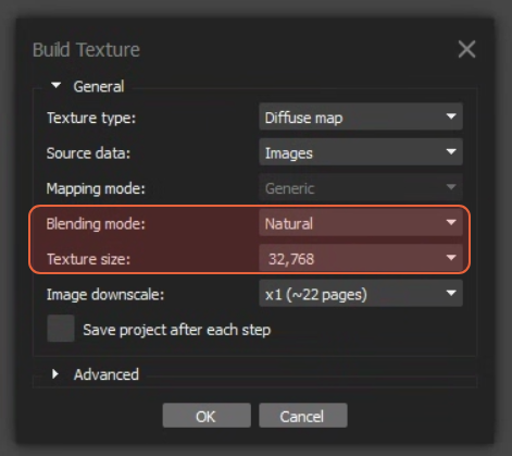
Configure Metashape to export textures with width and height that are a power of two — e.g., 8192×8192, 16384×16384, 32768×32768. We recommend a Texture size of 32,768 and a Blending mode of Natural. For texture count, select the Pixel size (m) option and let Metashape choose based on photo count and distance to subject. See Are there ideal dimensions for texture files?.
Step 3: Export the Model (OBJ)
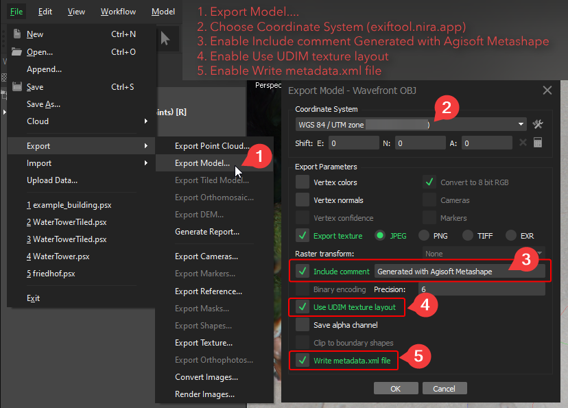
File > Export > Export Model…
Save as type: Wavefront OBJ (
*.obj).You can use Local Coordinates (m), but a Georeferenced Coordinate System is strongly preferred (see Step 1).
Enable Export texture (JPEG), include the comment Generated with Agisoft Metashape, enable Use UDIM texture layout, and Write metadata.xml.
Step 4: Export the Cameras (XML)
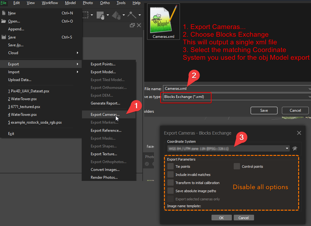
File > Export > Export Cameras…
Save as type: Blocks Exchange (
*.xml). Suggested filename:Cameras.xml.The Coordinate System must match what you chose for the OBJ export.
Disable Tie points, Control points, and all other options so the XML stays small.
For laser scan data with 360 panoramic images, match the panoramic export settings shown in Metashape.
Verify Before Upload
Model exported as OBJ (not a Tiled Model).
Coordinate system is cartesian (UTM or confirmed EPSG), and the same for OBJ and Cameras.
Textures are power-of-two dimensions.
metadata.xml written alongside the OBJ.
Filenames contain no commas.
Step 5: Upload to Nira
Upload all of the following together:
Mesh:
.objand.mtlfilesTextures:
.jpgfilesCameras: BlocksExchange XML
Coordinate system geolocation:
metadata.xmlPhoto files:
.jpg,.png, or.tiffLaser data with embedded panoramas (if applicable):
.E57files
After upload, your photos are available via the Show Photo… button.
⚠️ Warning: Ensure your photo filenames do not contain comma (
,) characters, or they may fail to associate correctly.
Troubleshooting
Problem: My uploaded model plots in the wrong location or as a blank box.
Cause: Exported in a non-cartesian system like WGS84.
Fix: Re-export using a UTM zone or a confirmed cartesian EPSG, and include metadata.xml.
Problem: The model in Nira looks lower-detail than in Metashape.
Cause: Texture settings or decimation during export.
Fix: Export power-of-two textures at the highest resolution practical, and let Metashape set texture count via Pixel size (m). See Supported Data & File Types for expected fidelity differences.
Problem: My photos didn't show up under Show Photo…
Cause: Missing camera XML, or filenames with commas.
Fix: Confirm Cameras.xml (Blocks Exchange) was uploaded and matches the model's coordinate system; remove commas from photo filenames.
Problem: My Tiled Model won't upload.
Cause: Metashape Tiled Models are not supported.
Fix: Export as OBJ instead.
Technical Notes
Tiled Models are not supported — OBJ only.
Coordinate system must be cartesian and identical across the OBJ and Cameras exports.
Textures must be power-of-two dimensions.
Photo filenames must contain no commas.
E57 with embedded panoramas is supported for laser-scan photo inspection.
Related Articles
Agisoft Metashape (Integrated Uploader) — Direct upload without manual export
Supported Data & File Types — What Nira accepts
Georeference & Map View — Coordinate systems and EPSG
Photo Inspection — Using camera data and E57 panoramas
DJI Terra and DJI Modify — Export guide for DJI workflows